From September 15-18 I covered about 56km over the trails and through the bush of beautiful Yoho National Park, near Field, BC. There were six adventurers in our group, myself, my dad, cousins Jim, Logan and Sam, and family friend Marty. This is a brief account (as brief as I can be anyways) of our “Leisurely Stroll” in the Rockies. It was a great adventure that I am very glad I did, and will definitely be able to use as inspiration for many other blog posts in the future!
Day 1 – Emerald Lake to Yoho Lake
8.0km over three hours, 400m elevation gain
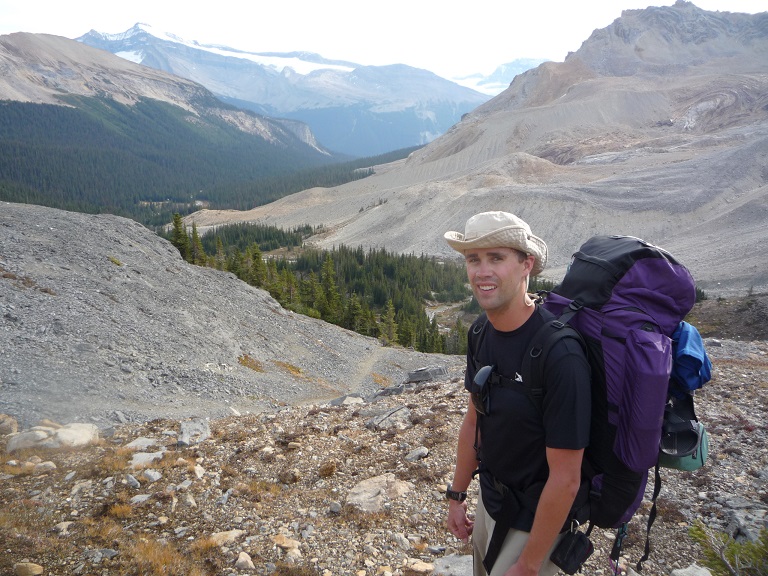
We started our journey from the parking lot of the beautiful Emerald Lake Lodge, near Field BC. After a tasty lunch and beer in the lodge, we did some final packing and were on our way.
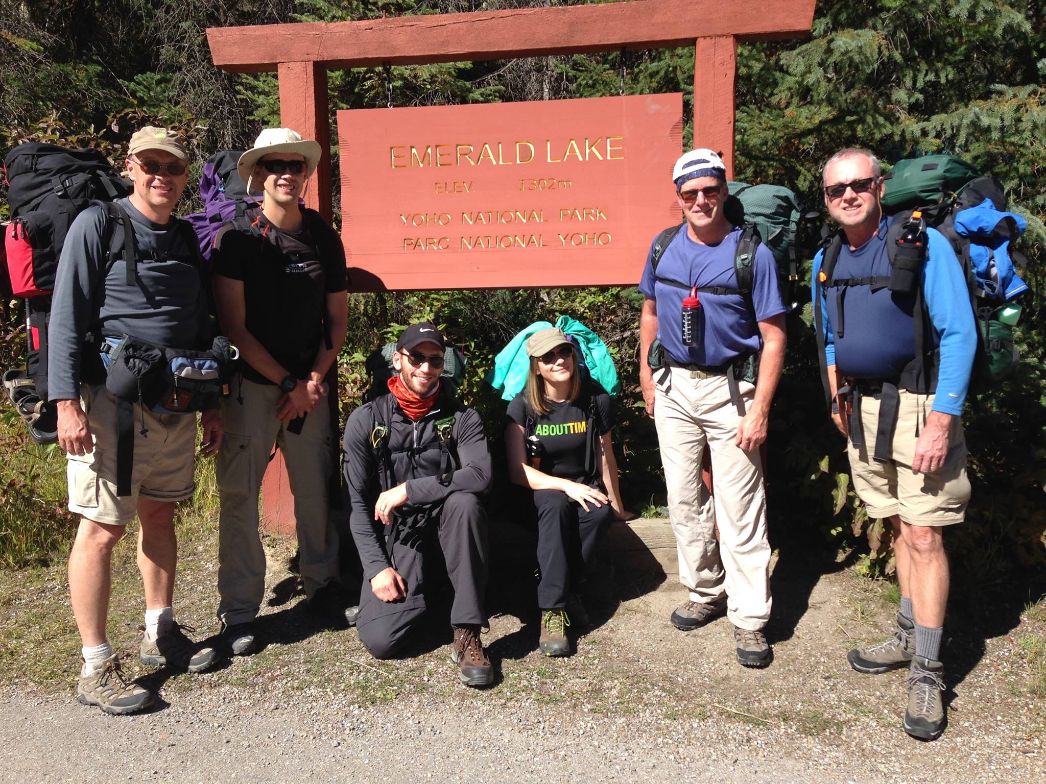
All packed up and ready to go! Dad (John), Myself, Logan, Sam, Jim and Marty (Left to Right)
The first hour or so of the hike was about as easy as could be expected when carrying 45 pounds on your back. We skirted the edge of the lake and then along a flood plain with a very gradual uphill incline. We could see the ridge ahead that we would be going up, from a distance it didn’t look too bad.

Looking back at Emerald Lake Lodge
Then we began to climb. Up, up, and up we went. It was a beautiful, sunny and hot afternoon, so there were many rest breaks for water, and of course to enjoy the view. Once you are in the trees and climbing it is very difficult to tell how much further you have to go, so there was a lot of “We’re almost there” followed by “Oh, I guess not yet!” But we persevered, and eventually were rewarded with a sign that read “Yoho Lake – 0.7km”.

Taking a break
The campground we stayed in at Yoho Lake the first night was a beautiful location. We arrived at about 4:30pm after about three hours of hiking, and happily spent the first half hour relaxing by the lake and taking in the beautiful views. Then after setting up the tents came the real reward, beer! When you are backpacking, everything is about weight, and aside from what you eat, you have to carry everything you take. Beer is not light, coming in at just under one pound per can. We did take one each for that first night, and boy was it worth it!

Time for a Beer!
With Happy Hour complete we set about preparing dinner, and the first night it is gourmet. The guys I was hiking with have a tradition of making fresh pizza in a backcountry oven (see picture below), and I can definitely see why the tradition carries on! The dough is freshly prepared the day before, so all you need to do is add sauce, toppings and cheese, bake for 15-20 minutes, and voila, tasty pizza!
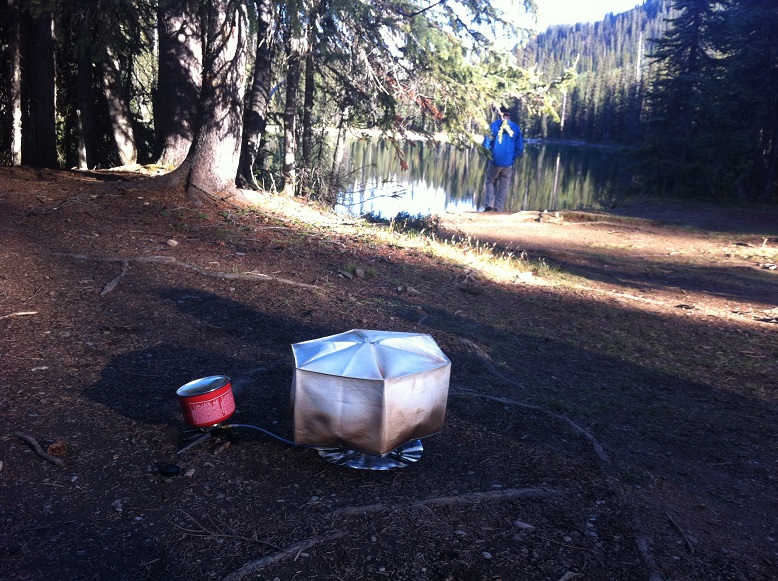
Backcountry Oven in action
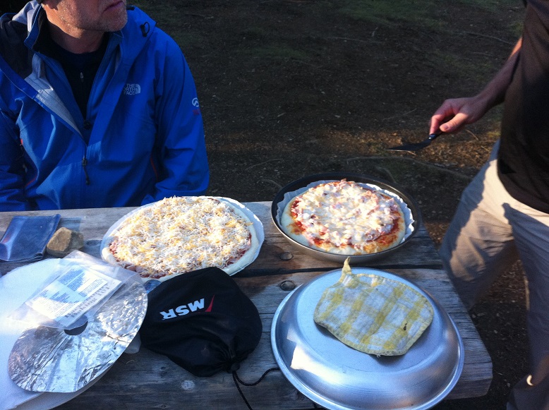
Fresh Pizza!
One of the unfortunate rules with backcountry camping is you are not allowed any fires, so once dinner is done, there is not a whole lot to do. Once our food was all hung safely on the bear poles we did play a round of a dice game called “Farkle” (which has new rules created every year), and then it was off to bed once darkness fell about 8:30pm.
Backpacking tents are not built to be spacious, they are built to be light. They are engineering marvels to a certain degree (the poles consist of two short aluminum spreader poles and two hiking poles used to support the middle), but they are not spacious. The tent I shared with my dad was about seven feet long and maybe five feet wide. Also, as it does get quite cold in the mountains at night, we were sleeping in mummy bags, which while great at keeping you warm, don’t provide much room to move around in. It did take a little while, but eventually I did drift off to a half decent sleep.
Day 2 – Yoho Lake to Little Yoho
10.7km over four and a half hours, 400m elevation gain
The sky begins to lighten around 7am, but the sun doesn’t get high enough to be over the mountains until closer to 8:30am in mid-September. Day two began about 7:30am with Dad sounding the morning alarm, the rest of us were feeling lazy and warm in our sleeping bags, so we didn’t really get moving until just after 8am.
One unfortunate side effect of two men sleeping in a tiny tent in near zero temperatures is condensation from our breath. Upon waking up I discovered the entire inside of the tent was covered in little water droplets and the outside of my sleeping bag was damp as well. It was quite the maneuver to get dressed and out of the tent without getting rained on, I only partially succeeded.
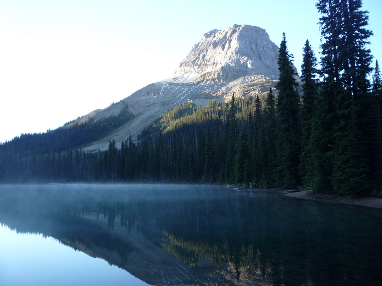
Sunrise over Yoho Lake
Breakfast was hot oatmeal, tea and bagels, oh and some dried banana, the warmth was much appreciated on a cold morning. The lake was like a sheet of glass with steam rising off of it, and made for some great pictures as the sun was rising. Once the sun made it above the ridge we started packing up, laying out our damp gear in the sun to start to dry.

Packed up and ready to start Day 2
By the time we started hiking around 10:30am the sun had really heated things up so we were all in our shorts and t-shirts and ready to go. The first few km of the day saw us climb higher out of the trees and up to the alpine. Once above the treeline we walked along the beautiful Iceline Trail, which runs North/South along a valley with Takakkaw Falls visible across the way. Trivia Fact – Takakkaw Falls is the third highest waterfall in Canada.

Takakkaw Falls
We encountered quite a few day hikers and tour groups along the Iceline Trail, all carrying far less than our 40lbs on their backs, although they were impressed by us! Around 1pm after hiking about 6km we decided it was time for lunch, so we stopped beside a small lake where we could fill up our water bottles (using very good filters). Lunch consisted of pitas with slices of salami and cheese, along with whatever other snacks and Gorp (Trail Mix) people had brought along.

Jump!
Stomach’s full and re-hydrated we carried on for the final 5km on to Little Yoho. The trail gradually started going down and eventually we were down into the trees and making our way down the valley to where the campground was. Just before arriving at the campground we stumbled upon the Stanley Mitchell Hut, an alpine hut maintained by the Alpine Club of Canada in which 24 people can sleep for about $40/night each. Alas, we did not have a reservation and the doors were locked, so we trudged on to our campground, which was a comparative steal at $9/night!
Even after only one day, the motions of setting up camp were pretty familiar, so after letting the tent hang in a tree inside out for a little while to dry out along with the other gear, we set up our tents and relaxed. Exploring the campground at Little Yoho we found a luxury outhouse, it had a window with a great view, was elevated way off the ground, and as far as outhouses go did not smell too bad at all!

Nature’s Drier
Dinner on the second night was freeze dried spaghetti, which with a little fresh cheese added was very tasty. We also had fresh cinnamon rolls for dessert. By the time we were done dessert, I was actually over stuffed! You need a lot of calories when hiking, but when you are snacking on nuts, candy and other high calorie food all day long, it’s not that hard to keep up!
After dinner we were visited by three women who were staying at a warden’s cabin nearby, one of the three was actually a Parks Canada employee, and when we told her of our plan to hike over the pass and down into the next valley (off trail), she was pretty surprised, and curious as to why we wanted to do that! The other two were European girls who are working their way around the world on tourist visas, so they had some interesting stories to tell and we had a good visit.
We finished the night off with a game of Farkle and then headed to bed when darkness fell, once again around 8:30pm, ready for another 11 hours of sleep. Not sure if it was the higher altitude or the overstuffed stomach, but night two was quite a restless sleep for me.
Day 3 – Little Yoho to Kiwetinok Valley
7.0km over four and half hours, 400m elevation gain, 400m descent
Over the first two days of the hike we had seen nary a cloud, but upon climbing out of the tents on day three, there were some clouds in the sky, but it still looked like it would be a pretty nice day.
We switched things up a little bit for breakfast, having some cinnamon muesli with freeze dried berries, which was very tasty but extremely filling. The package said it fed two, but it easily could have satisfied three people! After warming up with some tea, we broke camp and headed out around 9:30am.
In order to save ourselves about half a kilometre of walking back to a bridge we forded a stream across to the trail on the other side. We had to put our weight on a slightly unstable log in order to do this, but we all made it across without falling in and carried on nice and dry.

Carefully crossing the stream
The first few kilometres of the day were spent going up to the top of the Kiwetinok Pass, which was a 400m gain in elevation over about 4km. There were some very steep sections in there, but with some regular breaks we made it to the top of the pass in just over two hours. The views from the top of the pass were amazing, looking back the way we came and also down the Kiwetinok valley, into which we were about to descend.
Great view heading up Kiwetinok Pass
The Kiwetinok Pass is where the official trail ends, so the plan for the rest of the day was to blaze our own trail down into the valley and then bushwack up and over a ridge that would take us down into the Amiskwi Valley on the other side.
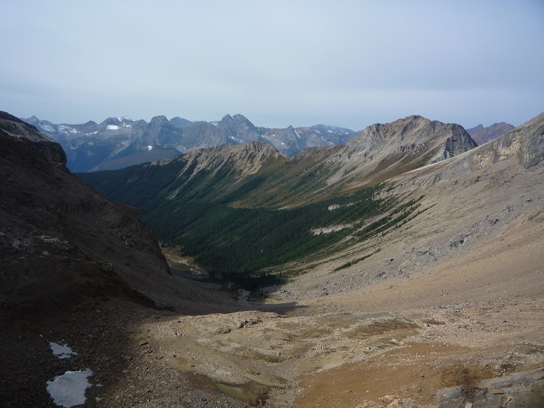
Looking down where we would be descending into the Kiwetinok Valley
After recovering our energy, having some snacks and studying the bowl to look for the best route down, we started off. The grade was pretty steep and the scree a mixture of loose and larger rocks. We had to go very slow to avoid a painful ankle or knee injury, and so we took our time. Eventually we got back down to the tree line, and picked our way through large boulders, streams, trees and other rocks, and after two hours of descending, finally made it to the valley bottom at about 2pm.
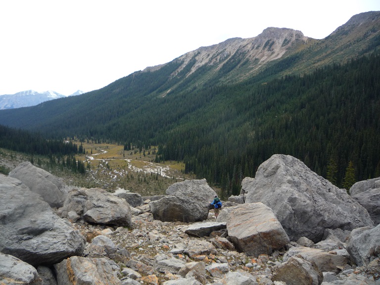
Navigating through some huge boulders
By this point everyone was quite exhausted and hungry, so we found a sun drenched island in the middle of the Kiwetinok River headwaters and rested and fueled up. As we ate we discussed the next steps, as the original plan was to continue on up over the ridge and into the next valley. We came to a consensus that it probably would take at least another four hours to do that which would mean we wouldn’t be at our next planned camping spot until close to 7pm that evening. With daylight being a precious commodity, we decided it would be smarter to camp where we were, and go over the ridge in the morning.
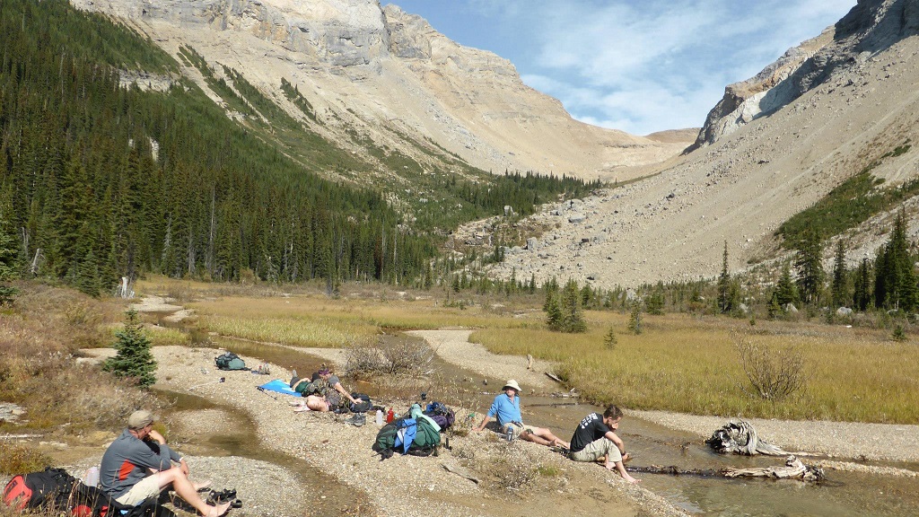
Time for lunch and a rest!
After looking around the area for a suitable camping spot, we settled on a rocky “island” in the dry river bed. The land on either side of the river bed was far too damp and boggy to set tents up in, so the rocks were the best option. As we were now camping in the bush we were careful to pick spots for the tents that disturbed the land as little as possible.
It was a nice sunny afternoon, so after setting up the tents and laying out the gear to dry, everyone had a nice relaxing nap in the sun. I also took the opportunity to bathe (read splash) myself in the ice cold waters of the nearby stream, although it was cold it felt so nice to rinse some of that sweat and grime off!
Prior to making dinner while there was still lots of light we then set about the task of finding suitable trees to use as bear poles to hang our food overnight from. Jim and I rigged up a sock on the end of a rope with a rock in it to get it up and over a high enough branch. We found two suitable trees fairly easily, and after a couple of unsuccessful tries were able to get the two ropes strung up high enough to keep our tasty food out of reach of any bears or other wildlife that may come along.
Dinner on the third night was Kraft dinner and hot dogs, along with some cinnamon coffee cake for dessert. Not having any tables to use, we had to do everything on the ground, which made it all take just a little bit longer. As the sky darkened we could see clouds approaching from the south, and they weren’t the whitest of clouds. Sure enough, just as we were about to head to bed after darkness fell the rain began. It wasn’t a particularly heavy rain, but it was fairly steady. We headed to bed just after 9pm hoping for a rain free morning.
Day 4 – Kiwetinok Valley to Natural Bridge Parking Lot
30.0km over eleven hours, 300m elevation gain, 1,100m descent
Unfortunately our wishes were not granted, the rain continued off and on throughout the night, and was still falling when we got up around 7:30am. We exited the tents to find the clouds grey with the socked in look of a steady drizzle. As we retrieved the food from the trees we noticed that the dry river bed was not quite as dry any more. However, as we had smartly setup our tents on an island, there was no risk of our camp flooding.
We ate a quick breakfast of oatmeal and bagels with some tea, and then broke camp as quickly as we could in an attempt to keep the gear as dry as possible, everything was a little damp though. After a quick weight check and some reshuffling to get everyone’s bags as close to 40lbs or under as possible we were off at about 9:15am.
The plan for the morning was to bush wack our way up the side of the ridge, go through the low point of the ridge and then down the other side into the Amiskwi Valley. We would then evaluate what to do from that point, but this was the first time we discussed the possibility of grinding it out and walking all the way back to the finish point, roughly 30km away even though our original plan had been to camp somewhere along the Amiskwi River.
We had picked a route that went up what looked to be an avalanche zone, which meant shorter trees to pick our way through. Once we got into the trees, it became pretty hard to see much more than a few dozen metres up the hill as the bush was quite dense. It was also soaking wet from the rain and drizzle. It did not take long for our shoes to become water logged and the pants to become wet. However, we had no choice but to carry on, so up we went.

Bushwhacking up the ridge, heading for the “notch”
We made it up to the treeline in just under an hour, and then continued on up the alpine meadow to the top of the ridge, zig-zagging all along. The drizzle was continuing and the higher we went, the cooler it got. We made it to the top of the ridge about 11am, but did not stay for long, as it was quite windy up there. Jim had studied satellite shots of the area and we knew there was an old skid road that had been used for logging and forest fire fighting back in the 60s or 70s off to the left of where we were, so we started heading down that way.

Descending into the Amiskwi Valley
Luckily the bush higher up was not too dense, and after about 15 minutes we were able to spot what looked to be a manmade cut in the forest below. Deducing that the cut could only be the old road, we made our way down a drainage valley in that direction, eventually heading back into the damp and dense bush. Just as we were beginning to think the road had just become overgrown, we stumbled into a clearing that was definitely manmade and was the beginning of a road!
We followed the skid road down through the bush as it cut back and forth, almost losing it a few times when the overgrowth got particularly dense. As we descended lower into the valley we were back into prime bear country, especially given the remoteness of the area and lack of regular hiking traffic. We were sure to stay together and make lots of noise as we went to keep any bears away.

Heading down the skid road
After about two hours of descending the road ended and we had made it to the east bank of the Amiskwi River. It was about 1:30pm, a little over four hours since we had left camp. The old fire road that we would be following all the way back to the parking lot was a little bit above the west bank of the river. There were no bridges to get across, but luckily the water was only about knee deep, so fording wouldn’t be too big of a deal.

Satellite shot of our route down into the Amiskwi Valley
Before setting about crossing the river we had a quick lunch of the usual pita, cheese and salami meat, and changed into some drier socks and gear. As we ate lunch the rain let up, but we were fairly sure it would start again, so we were prepared. We discussed our options, and with everyone now wet and not having the best of time, we decided to go for it and walk the 23 remaining kilometres all the way back to the cars. We knew darkness fell about 8:30pm, so once we got across the river we knew we would have about six hours to walk the 23 kilometres, which meant we would have to maintain a pace of 4 km/hr. It would be tough, but as long as the road wasn’t too overgrown we felt it was definitely doable.

Logan fording the Amiskwi River
With the six of us safely across the river by 2:30pm, we headed up into the bush in search of the fire road. Luckily the road wasn’t too far from the river, and after about 10 minutes of bushwhacking, we were onto the fire road. With a hard left turn we were on our way out, towards warm vehicles, fresh dinner, a hot shower and warm dry beds.
I have a GPS watch that I had been using off and on over the hike, so I was monitoring our pace for the first few kilometres of the march, and we were making a solid 4.5 km/hr even with a break every now and then for water. The light rain continued to fall, and our feet and boots were all quite wet, but we knew every step we took we got a little bit closer. The forestry road we were walking along was obviously no longer maintained, but for the most part it was still pretty clear and easy to walk on. There were sections where the bush had encroached and we had to bushwack a little bit though from time to time.
The fire road was easy to follow through, which was good, as we were basically on autopilot, moving along towards our end goal, without too much thought in the matter. Aside from one point along the trail where we arrived at an old logging camp of some sort and had difficulty finding where the trail continued, it was really kilometre after kilometre onwards through the bush.

Making our way down the Amiskwi Valley Fire Road
With 8-10 km left we started to see fresh bear signs on the trail, paw prints and some fairly fresh bear scat. The prints were mostly going the opposite direction, which was good, but some looked to be going our direction as well. They were fairly small, so likely black bears, and we just continued on making lots of noise, talking to the bears, and hoping to make them well aware of our presence. If there were any bears around us, we did not see them, but I’m sure they were entertained by our random ramblings and singing as we plodded along.
By the time 7pm rolled around I could tell from my watch that we were only about 3km away from the end point as the crow flies (straight line), and I started calling out the distance. Unfortunately, the trail did not follow the straight line distance, so it ended up being about 5km further to the end. By this point everyone’s feet, legs, knees and hips were becoming quite sore, and any time we stopped it was becoming increasingly difficult to get moving again. The solution to that problem of course was to not stop very much!
Just after 8pm we arrived at the river, and the full gravel road that would take us the final half kilometre or so to the finish, we had just about made it! Sure enough, about 8:15pm, the distance to destination on my watch read 0.00km and we were in the parking lot at the natural bridge. We had accomplished our goal, walked 30km over eleven hours, and made it to the finish line!
I had stashed a few cans of Coors in my Dad’s trunk for this occasion, and I wasted no time in cracking them to celebrate the moment with Marty, Logan and Sam as Dad & Jim drove the 8 minutes back up to Emerald Lake to get the other car. I had also stashed a clean and dry change of clothes in my Dad’s car, which I promptly changed in to, and boy was it nice to put on dry shoes after walking in soggy boots for eleven hours!
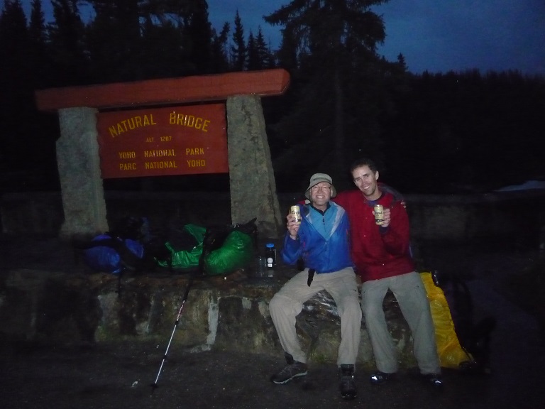
Celebrating the successful completion with a cold beer!
Once Dad and Jim came back we loaded the bags into the vehicles and hit the highway, it was now dark. We agreed to meet up at the Boston Pizza in Canmore for a late dinner, as Jim, Marty, Logan and Sam were going to stay the night in Canmore since they don’t live in Calgary, while Dad and I would go all the way home to Calgary. We creaked and stumbled in to the Canmore BPs around 10pm, and savored a hot meal and a beer while we reflected on the journey and celebrated the accomplishment.
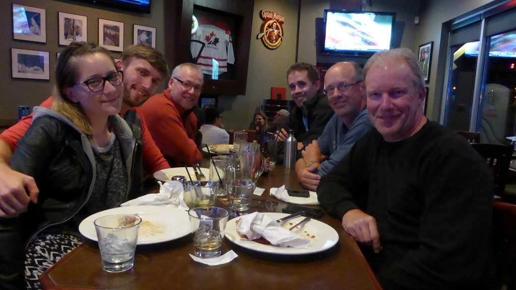
Enjoying a well earned hot meal at the Canmore BPs
All in all, the hike was a fantastic experience for me. The weather for the first three days was amazing, and even though the last day was rainy and cool, we were prepared for it. Also, there is something to be said for getting away from all of the distractions of modern society and into the pristine wilderness where Mother Nature and living in the moment truly does rule. While walking 30km in one day was definitely not in the original plan, the fact that we accomplished that feat is definitely something I am extremely proud of. The adventure would have not been nearly as much fun if it hadn’t been with such a great group of people, and I am very glad they were there to share the experience with me.

Our route over the four days: Day 1 = Purple, Day 2 = Yellow, Day 3 = Blue, Day 4 = Red


Pingback: No TV Challenge – Update #1 | Kevin's Corner
Wonderfully written, you captured the essence of the journey, comradeship, friendship, fun and the simple adventure we experienced. We were able to finally tame this beastly hike after several attempts [this is why we decided to do this hike Ms Park Ranger 🙂 ]. And enjoying a cold beverage and hot meal together was icing on the proverbial cake! A treasured memory in one of Canada’s National Parks.
LikeLike
Thanks for the kind words my friend, glad you enjoyed it!
LikeLike